Sandvik Mining Elevates Operational Intelligence with My Sandvik Geo
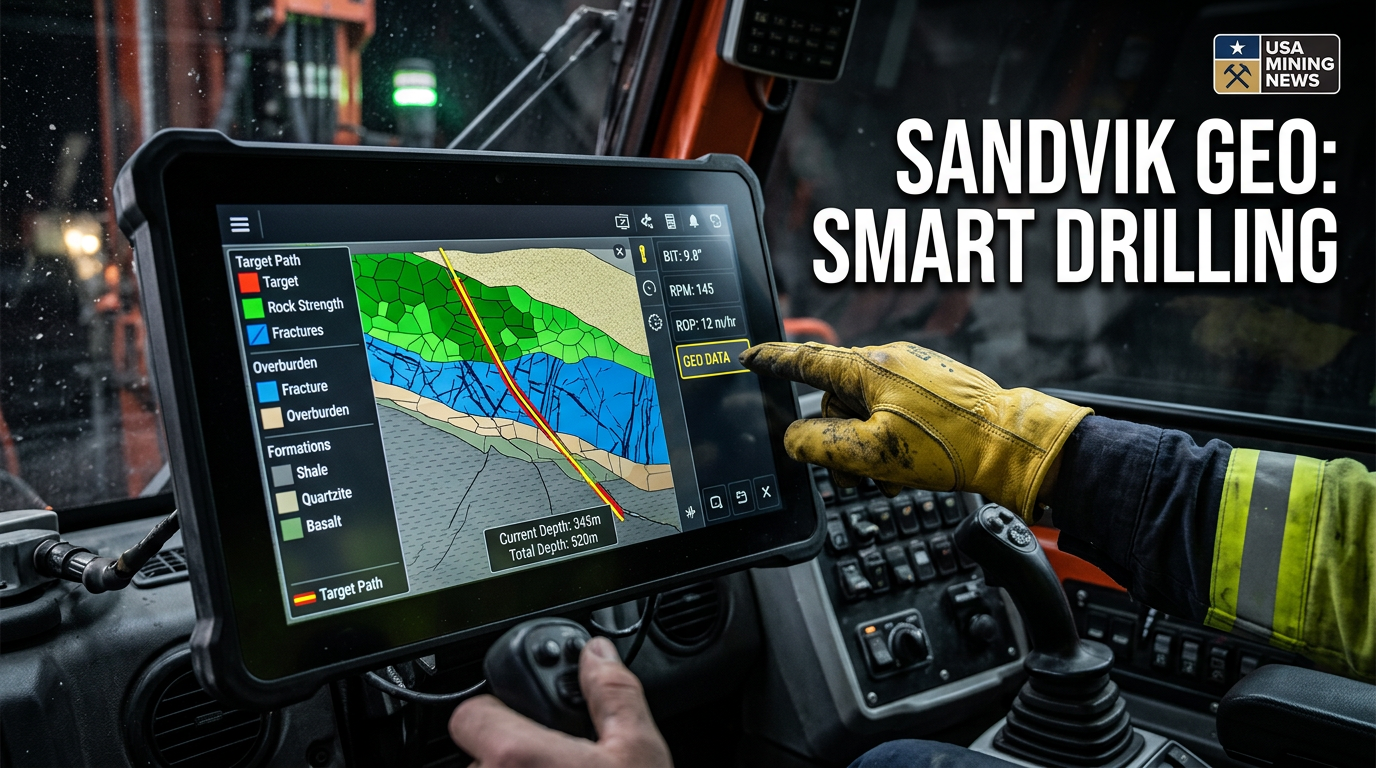
In a significant stride towards advanced digital transformation within the mining industry, Sandvik Mining announced on March 3, 2026, the launch of My Sandvik Geo, a sophisticated cloud-based digital service. This new offering is engineered to provide mining operations with unprecedented real-time access to critical subsurface conditions, effectively converting raw drilling measurements into actionable geological and geotechnical insights. The initiative underscores Sandvik's commitment to leveraging digital solutions to enhance efficiency, safety, and productivity across the global mining landscape.
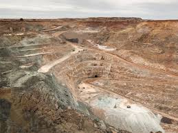
My Sandvik Geo is specifically tailored for surface top-hammer drilling activities, a foundational element in many open-pit operations. By enabling a deeper understanding of the ground beneath, the service is poised to revolutionize planning, optimize blasting outcomes, and ultimately drive increased productivity in a sector constantly seeking marginal gains and operational excellence.
Transforming Raw Data into Actionable Intelligence
At its core, My Sandvik Geo is a powerful analytics engine designed to process and interpret a vast array of drilling measurements. This includes crucial Measure While Drilling (MWD) data, which captures various parameters as drilling progresses, alongside precise drilling coordinates. The service goes beyond mere data collection, transforming these raw inputs into practical, easy-to-understand insights that are invaluable for operational teams.
The range of insights provided is comprehensive, covering critical aspects of the subsurface environment:
- Rock Strength: Crucial for determining optimal drilling and blasting parameters.
- Overburden Characteristics: Information on soil and loose rock layers covering the desired mineral deposits.
- Fractures and Discontinuities: Identifying structural weaknesses that can impact stability, safety, and blast performance.
- Drilling Accuracy: Evaluating how closely actual drilling paths adhere to a planned trajectory.
- Planned vs. Actual Execution: Providing real-time comparisons to identify deviations swiftly and enable immediate adjustments.
These insights empower mine operators and engineers to make more informed decisions, moving away from assumptions to a data-driven approach that minimizes risks and optimizes resource utilization.
The Four Levels of Data Transformation
Sandvik has structured My Sandvik Geo's data processing into a methodical four-stage framework, ensuring that information progresses from raw signals to strategic wisdom:
- Data Level: This initial stage involves the direct capture of raw signals emanating from the drill rig. These are the fundamental, unfiltered measurements of various drilling parameters.
- Information Level: Raw signals are then transformed into meaningful values. This includes interpreting raw data to quantify rock hardness, identify discontinuities such as fractures and geological contacts, and characterize overburden. This stage makes the data comprehensible.
- Knowledge Level: Building upon the interpreted information, the platform develops comprehensive geological models within the My Sandvik ecosystem. These models provide a contextual understanding of the subsurface, illustrating patterns and relationships that inform operational planning.
- Wisdom Level: The pinnacle of the process, this stage delivers actionable recommendations derived from the geological models and real-time insights. These recommendations are designed to inform strategic decisions, facilitate ongoing process improvements, and enable proactive adjustments in mining operations.
This progressive layering ensures that users receive not just data, but genuine intelligence that can be directly applied to enhance operational performance.
Operational Benefits and Industry Impact
The launch of My Sandvik Geo addresses several pervasive challenges in the mining industry, promising tangible benefits across various operational facets:
- Enhanced Blasting Precision: By accurately identifying rock strength varieties and geological structures, the service allows for more precise tailoring of blast designs, optimizing fragmentation and reducing undesirable outcomes like flyrock or costly secondary breakage. This translates to more efficient material handling in subsequent stages.
- Improved Safety: The real-time identification of fractures and voids within the rock mass is a critical safety feature. Such discontinuities can pose significant risks during drilling, blasting, and excavation, including potential ground collapses. By revealing these hazards proactively, My Sandvik Geo enables teams to implement preventative measures, thus safeguarding personnel and equipment.
- Better Drilling Quality: Detailed accuracy insights allow operators to monitor and correct deviations from the blast plan in real time. This ensures that boreholes are positioned correctly and drilled to the intended depth and angle, which is fundamental for effective blasting and overall mine design compliance.
- Efficient Use of Explosives and Materials: Understanding the subsurface conditions with greater clarity enables engineers to fine-tune explosive loading and material usage. This optimization not only reduces operational costs by preventing over-drilling and over-charging but also contributes to environmental sustainability by minimizing the overall consumption of resources.
- Real-time Deviation Visibility: The ability to track deviations from the blast plan in real time is a game-changer. It empowers operational teams to make swift, informed adjustments, ensuring that high standards of quality and efficiency are consistently maintained throughout the drilling and blasting sequence.
For mining professionals and investors, these benefits translate into tangible improvements in the bottom line: reduced operational costs, increased throughput, and a safer working environment. In today's volatile commodity markets, such efficiencies are not merely advantageous but imperative for competitive advantage and long-term viability.
Integration within Sandvik's Digital Ecosystem
My Sandvik Geo is not a standalone application but an integral component of Sandvik’s expansive cloud-based digital ecosystem. This strategic integration is crucial, as it allows for seamless data flow and interoperability with other digital tools employed in mine planning and operations. Specifically, the service can export its rich dataset to widely used mine-planning software, such as Deswik, a leading platform for mine design and scheduling.
Once activated, the drilling data captured by Sandvik's rigs automatically flows to the cloud, making visualization and analysis straightforward and immediate. This automated data pipeline eliminates manual data transfer, reduces the potential for human error, and ensures that decision-makers always have access to the most current information. This seamless integration philosophy reflects Sandvik's broader vision of a connected, intelligent mine where data flows freely between equipment, software, and personnel to optimize the entire value chain.
This digital push is further exemplified by Sandvik's recent corporate activities. Just a month prior to the My Sandvik Geo launch, Sandvik agreed to acquire ThoroughTec Simulation, a South African company renowned for its advanced equipment simulators and simulation-based training solutions for the mining industry. This acquisition complements the digital ecosystem by enhancing operator training and skill development, further solidifying Sandvik’s position as a holistic solution provider for the modern mine. The synergy between tools like My Sandvik Geo and advanced simulation training creates a powerful environment for both operational excellence and workforce development.
The Future of Mining: Data-Driven and Proactive
The introduction of My Sandvik Geo represents a significant milestone in the ongoing digitalization of the mining industry. It underscores a fundamental shift from reactive problem-solving to proactive, data-driven decision-making. Historically, geological uncertainties have been a major source of risk and inefficiency in mining operations. By providing real-time, granular insights into subsurface conditions, Sandvik is empowering mines to mitigate these uncertainties more effectively.
This service aligns perfectly with broader industry trends towards smart mining, automation, and the Internet of Things (IoT). As mines increasingly adopt connected technologies, the ability to collect, process, and act upon vast quantities of operational data becomes paramount. My Sandvik Geo offers a specialized, yet highly impactful, piece of this larger digital puzzle, focusing on a critical phase of the mining cycle: drilling and blasting.
Looking ahead, the success of platforms like My Sandvik Geo is likely to drive further innovation in data analytics, artificial intelligence, and machine learning applications within mining. The insights gained from such systems could be fed into predictive maintenance models, autonomous drilling algorithms, and even adaptive mine plans that adjust in real-time to changing geological conditions. As the industry continues its journey towards zero-harm, carbon neutrality, and maximum productivity, intelligent digital services will be indispensable tools in achieving these ambitious goals.
For mining companies, embracing such technologies is no longer optional but a strategic imperative. My Sandvik Geo offers a clear pathway to unlocking new levels of efficiency, safety, and profitability by putting actionable intelligence directly into the hands of those who need it most – the teams on the ground.